Okanogan Outdoor Education - 2001
Majestic Mountain via East Creek
[an article from the Kettle Range Conservation Group Newsletter, Fall,
2001)]
Semi-primitive Recreation
Essay by George Wooten

Canyon Creek.

KRCG recently sponsored a hike up Canyon Creek to Majestic Mountain on the Okanogan NF. This part of the Golden Horn Roadless Area, comprises most of the view from Harts Pass west to Highway 20. Although the area is managed primarily for semi-primitive non-motorized recreation, most people are surprised to learn that Golden Horn isnt in the Wilderness, nor even roadless. Motorized use is permitted well beyond Harts Pass in several mining operations.
This hike provided an opportunity to critically examine the cumulative effects of a century of mining in an area designated for semi-primitive recreation. KRCG and others recently prevailed in a court case against the Okanogan NF, which found that recreational projects require cumulative effects analyses, just as with any other projects.
Projects in this area include expanding mining operations on the New Gold Hill Mine on East Creek (call Don Phillips, 509-997-2131 for more information), ongoing operations and road use at the Azurite Mine on Mill Creek, Chancellor and along Canyon Creek, rebuilding the Slate Creek Bridge to the Azurite Mine (call Jennifer Zbyszewski, 509-996-4021 for information), and associated road and trail maintenance activities. In actuality, only the Gold Hill Mine is undergoing a thorough review. The other activities, including recreation, are a hodgepodge of afterthoughts lacking an objective plan. Canyon Creek owes its largely pristine character as much to lack of attention as to its formidable landscape.

Gold Hill Mine adit
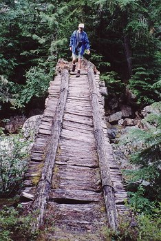
From Highway 20 our trail traversed a steep and narrow gorge about 500 feet above Canyon Creek, through splendid old growth forest. We found trees over 6 feet in diameter growing in verdant abundance with a diverse evergreen understory on a thick and continuous cover of mosses. We were even treated to a spotted owl flying past our camp on the second day (Hoooh!).
The main human impacts in Canyon Creek depend on the type of roads, trails and permits required. Passenger vehicles are allowed only between Harts Pass and Slate Creek, whereas snowmobiles, mountain bikes, ORVs and motorbikes can legally go an additional six miles to Chancellor under an existing use clause that allows miners to keep the road open. Motorized driving on the Cady Pass road is done through permits to mine operators, as are motorcycles on East Creek and Canyon Creek between Highway 20 and Mill Creek. Non-motorized human impacts include trail maintenance, hunting, riding, hiking, mining (which ranges from recreational gold panning, semi-recreational sluicing, semi-semi-recreational dynamite blasting, earth-moving with heavy equipment and helicopters, and building maintenance). Despite all this activity, only newly funded projects result in NEPA planning, which at this point, is limited to the New Gold Hill Mine proposal, which KRCG recently commented on. Currently, this appears to be the only large mine in the area with likely prospects for expansion at todays prices.
The following list describes some of the cumulative effects occurring in the semi-primitive non-motorized recreation area of Canyon Creek.
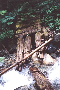
Trail maintenance. For starters, the bridge span was out at Rawleys Chasm, so we didnt risk going down the old side trail to see the historic junk pit there. The trail above Mill Creek bridge was wiped out this spring, rebuilt this summer, and wiped out again before we got there. Trail maintenance was nil north of Mill Creek, where the trail becomes a mere crumbling smudge on the side of a 500-foot shifting slope. The trail leading from Mill Creek to East Creek apparently hadnt been cut out for a decade or so, but was easy going through the open, mature forest. Apparently trail maintenance funds ran out about a third of the way from East Creek Trailhead.
Trail maintenance on Canyon Creek is on an every-other-year basis, and usually lasts about three months before nature takes it out again. This is a special management situation, for a special type of trail, but it deserves credit for preserving Canyon Creek from the wandering hordes. Trail costs are kept to a minimum, traffic is sparse, and there is an air of the unknown and possibly dangerous lurking here. This is an area for the adventuresome, where anything could happen, and not all of it fun: it is semi-primitive and non-motorized, but deserves to be changed from recreation to Wilderness!
The preferred alternative of the Gold Hill Mine project would expand the extent of the mining operation, however this would be compensated to some extent by requiring a new operating plan, posting of bonds, and requiring more stringent environmental protections. In addition, the trail from East Creek to Mill Creek would be re-routed to avoid the mine and helicopter pad. This would protect hikers from what one miner did to yours truly - shot repeatedly in my direction over the course of a half hour because the trail happened to be in his firing range.
Wildlife. Reclusive species such as grizzly bears that may have been isolated by sporadic trail maintenance for many years may find their habitat invaded when a trail, say, East Creek Trail rebuild, suddenly becomes popular. Now that this is being proposed, we must be sure that the Forest Service is candid about the potential affects of this change, as the rebuild would move the trail closer to prime old growth, while hiding the activities of the mines from public view.
Wildfire. In the late 1980s, a wild fire burned on Mill Creek. It didnt threaten any resources and it cleared out the fine fuels while rejuvenating good mountain goat habitat. The Forest assigned a small crew to supervise the fire as it burned itself out over the course of the season. This is a good example of the benefits of restoring fire into the ecosystem, except for one small problem - the fire was caused by careless campers and technically it should have been suppressed. The very good management of this fire had to be swept under the rug because there was no fire management plan that would allow for this sort of supervised burn, other than sending in minimal supervisory crews, which poses a new set of risks. Today this fire might have been managed differently, and tomorrow differently still. What is needed is a flexible, coordinated plan that includes contingencies for controlling different types of wildland fires.
What if wild fire threatens the equipment and resources at the New Gold Hill Mine or spreads into the adjacent occupied spotted owl habitat? Without a fire management plan, fire managers might feel it was necessary to build bulldozer lines to protect resources in the vicinity of the mine.
Campgrounds. Reminders of bygone mining days still linger along the Canyon Creek Trail, including various old test digs and a few junk piles. But at Mill Creek, there is debris of more recent vintage: a stack of logs 32 feet long was dumped beside the bridge 10 years ago, still awaiting rebuilding the bridge. These were helicoptered in following clearcut logging of the Lone Fir campground (locally referred to as No-Fir Campground), victim of the public liability laws. The rebuilding project fell victim to funding cuts in the trail maintenance budget, which is interesting, since the timber sale was a huge profit, and brought in one of the highest bid prices ever paid for timber in the Region. It didnt matter that the No-Fir Campground timber was in prime, riparian, old growth, spotted owl habitat, what mattered was that this campground was in a forest, and forests are made of trees which get big and eventually fall, and thus the Okanogan NF was a sitting duck for a liability lawsuit in the case of a camper getting squished.
The Forest has already lost the big old trees at Black Pine Lake Campground and now stands to lose those at Klipchuck Campground (call Leahe Swayze at 509-997-9753 for information). Campgrounds are administrative sites, exempt from many other rules protecting trees. Barring tort reform, we may just have to be satisfied with camping on undeveloped, dispersed sites, where the risk of getting crushed is ones own responsibility, not the publics.
User fees. Currently, you are liable for payment of user fees for parking at any trailheads, such as the one at Canyon Creek. User fees, commonly known as the Fee Demonstration Program, were conceived by the Blue Ribbon Coalition, a consortium of petrochemical, automotive and amusement park companies, as a means to privatize and commercialize public lands. The program was originally supposed to undergo a thorough review after a thirty month trial period, however it has been extended into a permanent program without review. The following is excerpted from the position statement of the Mazamas, a well-respected national outdoor organization:
It is not sound policy to charge use fees for low-impact recreational activities such as climbing and hiking while subsidizing such destructive activities as logging and mining. The recreational fee demo program has the potential to turn recreational management of our public lands from a public service to the tax payer to a commercial enterprise orientation, and this is the true issue. Recreational interests that have the heaviest impact on the land but which generate the highest revenue, such as downhill skiing, resort development, power boating and off-road vehicle use will end up taking precedence over lower impact activities such as hiking, cross country skiing and camping .
Prominent signs at Canyon Creek and East Creek Trailheads warn visitors to pay their user fees. Studies have shown that user fees discourage low-income trail users from using an area. However unfair this might be, it is conjectural whether this lost constituency would affect the landscape differently.
Roads. Four miles of road link the Azurite mine to Harts Pass over Cady Pass. This road was originally an old mining road to the Azurite Mine, which fell into abandon over the years until being re-opened in the 1990s for exploratory mineral work. Roads in this area of narrow canyons quickly unravel if not constantly manicured, creating chronic sores in the landscape. Another road with severe cumulative effects is the 12 miles of old road to Chancellor, the lower six of which are no longer managed by the Forest Service. Instead miners manage it on their own, under a quarrelsome, quasi-legal situation.
Mines. Although this area has been spared the fate of large-scale pit mining, several lode deposits of gold, such as the Barron Mine near Harts Pass, opened the area up as a mining district. The Cady Pass road leads to huge, sterile tailings piles at the Azurite Mine, which stretch a quarter mile along Mill Creek, burying several small streams and springs. Mineral-stained puddles ooze from the piles into Mill Creek and a lingering odor of petrochemicals hangs in the air for miles. This is the big, nasty, secret skeleton in the closet of the Okanogan. The cumulative effects are piled a hundred feet deep here, but remain hidden from the eyes of EPA and Washington DOE, agencies that might be compelled to take action if they were to learn of it officially. Although an EIS was produced upon reopening the road, it set a record for brevity, with a total of only a single comment received (call Gregg Knott, 509-996-4027, for more information on the Azurite Mine).
Conclusion. The Canyon Creek semi-primitive recreation area could become part of the Golden Horn Wilderness, but serious environmental problems still have to be reconciled. Several of the mines will continue to operate until they go out of business, after which cleanup of the hazardous waste and tailings will likely fall upon the public coffers. Popular roads like the one to Harts Pass will remain popular except for grace periods following bad accidents; other roads and trails will remain a battleground between man and nature. Industrial interests will continue to covet the old growth in Canyon Creek. Fires will come and go, along with the political maneuvering and finger-pointing each time resources are threatened, along with the call to salvage whenever the public is distracted by larger events. Laissez-faire management will eventually give way to planned activities.
I personally hope that we can let Canyon Creek Trail remain wild, and restrain from the urge to improve it over our current system. Instead, lets concentrate our efforts on improving popular, hardened sites, rather than dispersing them across the landscape. There is a wonderful old trail that runs about 40 miles along Highway 20 between Mazama and Ross Lake, right where visiting travelers could most benefit from a brisk stretch. Every mile or so, this abandoned stretch of trail is marked with a bold, green diamond proclaiming its heritage - the original, Pacific Crest Trail (click to enlarge).